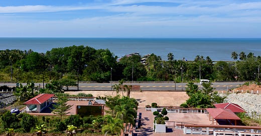
Turn left while heading away from the bulk of Thailand and you’ll quickly bump into the Cardamoms, a mountain range whose steep slopes mark the southwestern edge of Cambodia. Turn right into the sea breeze, and the Gulf of Thailand extends to the horizon. Here in the lengthy southeastern tail of Trat province, the political and natural geography is laid out plainly in front of you.
Resembling an arm or a monkey tail on a map, this ‘panhandle’ reaches for 70 km from the rest of Trat. Ending at a border crossing that links the Thai and Cambodian coasts, most of the terrain is so narrow that only one road — Sukhumvit or Highway 3 — can be used for through travel. (Yes, it’s the same Sukhumvit that begins 280 km away in Bangkok.) Unless Cambodia bound, people rarely come this way.
But the tail of Trat is worth a visit if you’re into offbeat travel or simply looking to side step the usual tourist path to nearby islands like Ko Chang, Ko Kood and Ko Mak. Now recovered from some fraught times over the past century, the area has photogenic fishing villages and plenty of sparsely developed beaches. Throughout our late 2020 trip, both the Gulf and the Cardamoms almost always remain in view.

Narrowest part of Thailand?
About an hour into the drive from Trat town we pull up to a road sign marking “the narrowest part of Thailand.” Only geography nerds like me appreciate this roadside ‘attraction’ where broad stairways cover a hillside topped by some pavement where you can gaze west and make out the mountainous profile of Ko Kood when the sky is clear enough. There’s even some exercise equipment.
At this exact spot, less than half a km of terrain separates the coast from the top of the ridge where Cambodia begins. Though it appears as little more than a geographical quirk today, the site is one of several along the 817-km border which hints at more than a century of territorial disputes between rulers on either side.

The modern demarcation results from decades of often-tense negotiations between the Siamese/Thai and the French, who colonized most of modern Cambodia from the late 19th to the mid 20th centuries. They also took over Trat province in 1904, only returning it to Siam in exchange for what’s now much of northwestern Cambodia two years later. If not for this colonial-era deal, Ko Chang would probably be in Cambodia today, while Siem Reap would be part of Thailand.
Isolated border disputes between Thailand and Cambodia continue more than seven decades after the French left the region. In fact, high-level Cambodians claimed that Ko Kood (they call it Ko Kong) belonged to their country as late as 1996.

It also turns out that this is not the only place claimed to be the narrowest stretch of land in Thailand. Over in Prachuap Khiri Khan, locals and their road signs say the same about a point where only 14 km separate the Gulf coast from the Myanmar border near Sing Khon Pass. Both claims are correct, but how?
Ko Kood lies around 50 km west of Trat’s ‘narrowest point.’ So, if you include this island and the sea in between, then Prachuap does indeed have the narrowest part of Thailand. But if you only count the mainland terrain between seacoast and border, no place is narrower than this pinch of the Trat tail.
Hat Lek to Hat Pailin
In this part of Thailand, you would only be traveling east on Sukhumvit if heading to Cambodia or, like us, to the easternmost villages and beaches spread along Thailand’s portion of the Gulf coast. Before the pandemic, this route bustled with vans full of backpackers and trucks using the coastal border crossing rather than the busier one up at Aranyaprathet / Poi Pet. Now the highway is almost empty.
In Ban Hat Lek we observe a 40-year-old bunker and stroll down to the scraggly little beach that both the village and border crossing are named after. When last here in 2015 we met a pair of Swedish backpackers taking a dip during the hour before their van departed for Trat town. For some travelers doing a regional trip, Ban Hat Lek is the first part of Thailand they ever lay eyes on.
Turning back northwest from Hat Lek, our goal is to stop at every accessible beach and village found on the tail of Trat.
The first is Ban San Chao, where we chat with a few people as they pick debris out of fishing nets on a roofed pier. Some locals speak a Khmer dialect in these parts, using petite motorboats to subsist off small-scale fishing. They often search for a type of sheatfish that’s sun-dried and sold in bunches threaded together.
Further up the road we meet a landmine disposal team in Ban Khlong Nam, a village of stilted houses set along a canal near the ‘narrowest part of Thailand’ site. As we chat with some of the team members, it becomes apparent that while the area is serene and peaceful nowadays, this was not the case only a few decades ago. Even today, violence continues due to unexploded ordinances along the border.
We spin through the larger town of Ban Khlong Makham and pull off for a hit of caffeine and a sample of seafood near the highway at Kaew Coffee. For 60 baht per bowl, their rice noodles come drenched in aromatic tom yum broth and stacked with kaeng, or mantis shrimp. The area is known for these tasty creatures that look more like aquatic centipedes with mantis heads than your average prawn.
Next up is Ban Khlong Yai, the largest town found this side of the provincial capital. Meaning ‘Town of the Big Canal,’ the name is also used for the district that covers the entire lower half of the Trat panhandle. Though not very picturesque, Khlong Yai is the area’s primary fishing hub with several markets where seafood is loaded into Bangkok-bound trucks. It also has a concrete pier that extends for three km offshore, a length that I reckon makes it one of the longest in Thailand.
The vibe mellows northwest of Khlong Yai in an area where the tail of Trat widens enough for us to turn off the featureless highway and cruise up a rural road closer to the coast. We stop at the squeaky sand of Hat Son Ngam, marked by a park with a tiny shrine to King Chulalongkorn near the mouth of Khlong Kood. In the shade of casuarina trees, we feed leftover sticky rice to some stray dogs.
A few km further lies Pailin Beach, accessed via a lumpy dirt road in a desolate area. A man on a pink bicycle shepherds three cows near the sea. From this point it’s possible to walk northwest up the beach for five km without interruption. We spot a few lodgings, such as the unexpectedly large Mango Beach Resort, but most of the sand is backed by shrimp farms and sandy lots full of unkempt vegetation.
Ban Chuen to Ploy Daeng
The tail’s center of tourism is Hat Ban Chuen. In an area that attracts very few tourists, that is not saying much. Though it’s the most popular beach on the tail with around 10 seafood restaurants and perhaps half a dozen lodgings, including the midrange De Vera Nio Resort and the cheaper Ban Chuen Beach Resort, the mood remains languid. We see only a few other people about.
We sit in the sea breeze at Tawin Restaurant and feast on a steamed white snapper to go with a heaping plate of pla mook kaeng karee, featuring fresh squid stir-fried with egg, scallion and Indian curry powder. Squid so tender that it melts in the mouth is a rare thing, but we find it here. With sea-view tables set beneath individual awnings, all of the eateries have similar menus and appearances.
As with many coastal areas in Thailand, erosion hit Hat Ban Chuen hard over the last decade. The chef at Tawin tells us that not much sand has been visible in front of her restaurant at high tide on most days in recent years. The failure of a concrete seawall that was installed several years ago to protect the beach becomes more apparent as we walk towards the north end of Hat Ban Chuen — or what’s left of it.
Here’s how the beach looked on a previous visit:
Seawater has infiltrated the depths below the wall, dragging away sand from underneath and forming a mini moat on the other side. Most land on the inland side of the wall has held its integrity thanks to the roots of casuarina trees, but most of the beach has been lost. At high tide, the only remaining dry sand is found at the far northwest end of Hat Ban Chuen near the Khlong Maru estuary.
Here’s how it looked close to the same spot where the 2015 photo was shot:

Up at the north end, we see just what’s been lost. Reminiscent of the brilliant sand on some of Ko Kood’s beaches, the grains at this remaining stretch of Hat Ban Chuen are white and soft like fine powder. As the sea rises and the concrete wall worsens erosion in the areas beyond its reach, we wonder if any dry sand will be left here next time we return. For now, we basque in how it feels on our toes.

Our next stop is Ban Mai Rut (rhymes with ‘root’), a scenic fishing hamlet with some well lived-in heritage architecture set along the narrow river of the same name. With stilted footpaths leading past riverside houses that double as eateries and shops selling an array of seafood products, the town is a highlight of the tail. You can follow stilted riverside footpaths all the way out to the shoreline.
Fishers anchor mostly small boats in Khlong Mai Rut and offload their catches straight into small shops and markets, creating picturesque scenes. We come across a few places to stay, including Mairood Resort north of the river and Ban Kamnan Homestay near the short but pretty Mai Rut Beach. Though both of our previous meals were great, we should have saved our appetite for Mai Rut.
Join The Roaming Cook on an eating tour in Ban Mai Rut.
After an hour lost perusing the seafood products, we return to Sukhumvit and look for the oddest beach of the day: Hat Ratchakarun. Named after an early 20th century Thai-style pavilion that still stands near the sea, this narrow beach and a wide tract of adjacent land is owned and overseen by the Thai Red Cross Society. We hand over an ID to a gatekeeper in a process that’s similar to entering Thailand’s military-controlled beaches, like Ao Manao near Prachuap Khiri Khan.
With lots of picnic tables in the shade to go with a Thai restaurant and simple rooms rented out by the Red Cross for overnight stays, the atmosphere at Hat Ratchakarun is similar in many ways to those military-controlled beaches. The difference is that while some of them are popular, few tourists make it to this one. We order a plate of som tam with salty mud crab and soak up the peace and quiet.
Sticking with the monkey tail analogy, we’re now approaching the ‘butt’ of Trat province’s southeastern tail. We stop briefly at a Centara-branded luxury resort that overlooks Thupthim Beach, but we’re told that only guests are allowed on the property and we can’t find another way to access the coast from the highway. I’ve always found it surprising that Centara maintains a resort down this way.
Instead we cruise four km north and discover a lane leading to Hat Ploy Daeng, a name that means ‘Red Gem Beach,’ though we find no rubies on this day. A lonesome seafood restaurant is closed, and the beachfront community center doesn’t appear to have been used for ages. Whoever built it also added a three-story observation tower, and I climb up towards the treetops as Chin strolls down below. It’s late afternoon and this is our last stop of the day. Time for a swim. 🌴
(Click here for a map pinpointing the places covered in this article.)
Fantastic article. Never been out east that far. Think it's about time I did. Cheers.
Great read, thanks