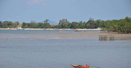
Ko Sukorn: The geography, culture and folklore of 'Pig Island'
Few of the travelers who visit this pastoral island in the lower Thai Andaman Sea are aware of its intriguing cultural heritage. (Island Nerd #10)
Welcome to the first of two articles on Ko Sukorn. To access the second one and at least four additional articles per month, a paid subscription costs $6 USD/month or $60/year.
Never have I encountered another traveler while riding the songthaew from Trang to Hat Tasae, where longtail ferries depart for Ko Sukorn. On all three of my trips to this arcadian island, I’ve shared these roofed pickups and banana-shaped boats with women in batik fabrics and men who muscle their motorbikes aboard. A kid in a school uniform might have been looking shy beside their mum.
Other travelers haven’t appeared until I’ve caught a saleng (sidecar motorbike taxi) over to the few low-key resorts found on Ko Sukorn’s west coast — and even then, I’ve never come across more than half a dozen foreigners at once. This makes it easy to meet the travelers who do happen to be there. More often than not, we chat about how so few of us ever pay this pastoral ‘Pig Island’ a visit.
Be they foreign or Thai, travelers tend to opt for Ko Mook and Ko Kradan when venturing to Trang province’s stretch of the lower Thai Andaman Sea. Ko Sukorn’s beaches lack the white-sand sparkle and luxury resorts of these smaller islands set 40 to 50 km to the north. Ko Sukorn is also harder to reach. Most of the travelers who are keen to go offbeat and glimpse island life in Trang choose Ko Libong, a larger island with a rare dugong habitat and some decent beaches to explore.
Ko Sukorn is sometimes summed up as merely an inhabited Muslim island with mediocre beaches that are only worth visiting if you’re after an exceedingly quiet atmosphere without the bells and whistles of mainstream tourism. Though not inaccurate, takes like these sell Ko Sukorn short. Peel back some layers and learn a little about its past, and the ‘Pig Island’ becomes more special.

Sand and water buffalos
With an area of 14 square km, the roughly nine-km long island of Ko Sukorn lies only four km south of Tasae Beach and the mouth of the Tasae River in the far southern reaches of Trang province. Take a boat due east from the southern corner of the island and you’ll eventually bump into mainland Satun province. This out-of-the-way setting is one of the factors that keep many tourists from visiting.
Most of Ko Sukorn’s flat and rolling landscape has been cultivated for agriculture, the most noteworthy exception being a three-km-long forest of mangroves in the northeast. Rubber groves cloak the western hills while coconut trees line parts of the coast and rice fields extend over much of the eastern flatland. Neither the paddies nor the water buffaloes are particularly common in Thailand’s islands.
Reaching for three km along the entire southeast coast, Hat Taeng Mo is the longest beach on Ko Sukorn, but not the finest. With brown and grey sand extending to squishy mud flats where a world of fingernail-size crabs emerges at low tide, this ‘Watermelon Beach’ has almost no development apart from the shaggy lane that runs behind part of it. Coconut trees stand here and there.
Further west lies km-long Hat Lo Yai, composed of softer sand that strikes a tan shade and dips into an offshore drop that makes for good swimming, even if the water stays murky for much of the year. The sea often ranges from sapphire- to Navy-blue in dry season, when watching the sun sink behind the cliffs of Ko Phetra and Ko Lao Liang can be entrancing. Though it’s the main tourism beach on Ko Sukorn, I’ve never seen more than a few folks lounging on Hat Lo Yai.
Further west as the landscape gets hilly and sparsely settled, the rocky Cabana Beach is named after the secluded budget resort built above it. Nearby Hat Lo Dalam (aka Hat Yao) rims the far northwestern shore and hosted one resort until a decade ago. It’s still a fine place to find solitude and go for a stroll atop the flat, hard-packed sand which extends to a hidden shoulder of limestone cliffs.
A deeper cut
Ko Sukorn and the island’s alternate name, Ko Muu, both mean ‘Pig Island’ or ‘Pork Island,’ though you’ll see no hogs, and pork is not widely available given the Halal dietary rules followed by the Muslim islanders. The most widely accepted claim of how the name came to be is that early inhabitants simply found the island full of wild boar, which were eventually rounded up and shipped away.
A folk tale begs to differ.
It holds that a local Muslim man fell for the daughter of a wealthy Thai Buddhist merchant who often anchored at the nearby trading port on the mainland. The pair fell in love and were married. Years passed before her parents finally visited unannounced and brought muu ping, or pork skewers. Their daughter refused to eat the pork and, for some reason, pretended not to recognize her own mother and father. Angered by this disrespect, her parents tossed the muu ping into the sea and watched it float to what henceforth became known as ‘Pork Island.’

Not related to the name, another folk tale that Ko Sukorn elders tell is worth sharing. Long ago, the ship owned by a Muslim buffalo trader from India capsized in a storm while making its way from Kantang down to Penang. Some 200 buffaloes and all of the crew drowned, except for the shipowner. He survived 15 days and 15 nights at sea by eating the flesh of a dead, floating calf. When he washed up on Ko Sukorn, the islanders spent another 15 nights nourishing him back to health.
The only certainty in these stories, as well as in another legend explaining how nearby Ko Lao Liang was named, is that a busy shipping lane operated close to Ko Sukorn when regional trading centers like Trang and Phuket were much more closely linked to Penang than Bangkok in the 19th century and earlier. While today’s roughly 2,600 islanders are seen as homogenized Thai Muslims, Ko Sukorn was settled gradually by people from many places who ended up here for many reasons.
As with many other islands in this region, such as Ko Mook, Ko Bulon and Ko Jum / Pu, the first people on Ko Sukorn are thought to have been semi-nomadic Urak Lawoi. After these ‘Sea People’ appeared, the island attracted quite a mix of people from parts of what are now Malaysia and Indonesia as well as Songkhla, Phatthalung, Krabi and other parts of Southern Siam. Before it was made part of Trang province last century, Ko Sukorn had loosely been rolled into Phatthalung.
This broad heritage combines with a relatively long distance from the nearest cities, and the bountiful land and sea, to explain why the people of Ko Sukorn developed an independent spirit and became self-sufficient through various forms of fishing and agriculture. While modern residents do ship supplies in from the mainland, much of what sustains them still springs from the sea and soil of Ko Sukorn itself. If you see a family eating rice with goat curry or fish with herbs and veggies, there’s a good chance that most of the ingredients came from the island.
A strong sense of community still emanates from a baby-blue mosque, primary school and health clinic in Ban Sai Mai, the island’s largest village and where the main pier is located. Its name, meaning ‘New Siam Village,’ is another hint at the mixed roots of Ko Sukorn’s heritage. The island community also encompasses the smaller villages of Ban Thung and Ban Laem further east, where two more mosques join another pier and primary school.
A trait shared by roughly 95% of the 2,600 residents is adherence to Islam, and in some ways this faith has intermingled with pre-existing animism. For example, the belief that spirits exist in the wood used to make longtail boats is complemented by a ceremony in which Allah is asked to watch over a boat, along with its passengers, before it enters the water for the first time or after it’s been repaired. Material offerings to the spirits, such as food, join the prayers to Allah.
Around 70% of the islanders are primarily employed in fishing, while 20% focus on the cultivation of coconut, cashew, several types of rice and the rubber trees that Chinese and Thai merchants introduced a century ago. The water buffaloes are a signature aspect of Ko Sukorn, but watermelon is its claim to fame.
Smaller than the watermelons found in most of Thailand’s grocery stores, the notably sweet melons from Ko Sukorn are grown along the edges of rice paddies near the sea, mostly along the southeast coastline. For many generations, these fruits have been harvested along with the rice during November and December. In fact, the local watermelon features prominently in the Bergfah Andaman Festival, when islanders join any tourists who are around to celebrate the end of another year with boat races, football matches, musical acts and a whole lot of eating.
Though tourism on Ko Sukorn began with a few bungalow resorts that mainlanders with connections to the island opened in the 1990s and early 2000s, some of the native islanders have since gotten in on the action by opening homestay lodgings. Often consisting of no more than a couple of bedrooms attached to houses in the villages, or spartan huts set beside the farms, homestays can be a great way for travelers to learn about local customs over meals shared with islander families.

How to get there
Last I checked, one daily songthaew painted dark blue was departing at 11:00 AM from the south side of the Municipal Fresh Market in Trang. It runs to the pier at the east end of Hat Tasae, where minimal parking is available. Most tourists ask travel agents near Trang Railway Station to ask for help finding the songthaew, which makes a pitstop in the market town of Yan Ta Khao. The local ferry costs 50 baht and runs frequently. Taxis to the pier can also be arranged in Trang. None of the high-season island-hopping ferries stop at Ko Sukorn. For more info on transport and where to stay, the Travelfish guide was last updated in early 2020. 🌴
Some of the info in this article came from the Koh Sukorn Subdistrict Municipality (kohsukorn.go.th).
Thank you for reading Thai Island Times, an independent newsletter sharing the beauty, challenges and distinctive identities of Thai islands and coastal areas.